Last time, I talked about what I felt was a gap in Muni service. I’ll try and sketch out a line that would fill in this gap.
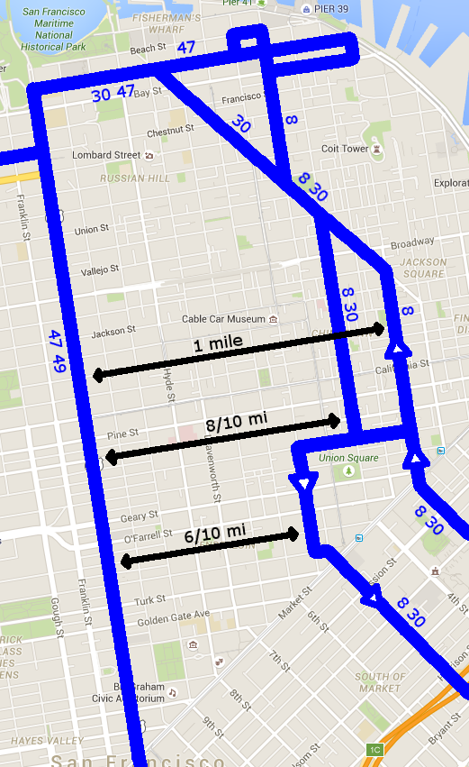
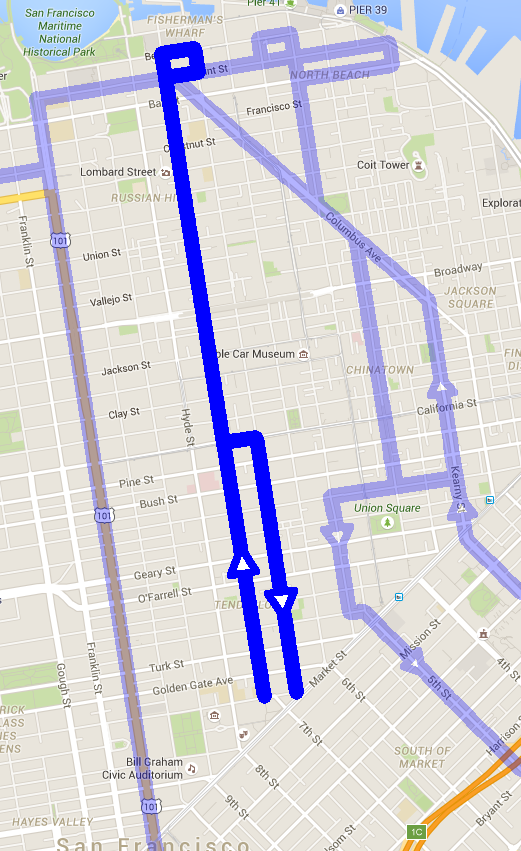
Since we are talking about a gap in service between Van Ness and Stockton, the best way to start would be to try and send a line right down the middle. As they are nine blocks apart, the middle lies between Leavenworth and Jones. We’re going to want to pick one of those streets to serve as the base for our line. A bus along this corridor will serve:
- Civic Center Station
- Boedekker Park on Eddy
- Tenderloin Playground on Ellis
- St. Francis Hospital on Bush
- Grace Cathedral and Huntington Park on California, bordering which are many large hotels as well
- The Pacific Ave neighborhood commercial district
- Michelangelo Playground on Greenwich
- The squiggly bit of Lombard for tourists, Yick Wo Elementary, and George Sterling Park if you’re willing to hike up to it
- Fay Park and the San Francisco Art Institute on Chestnut
- Russian Hill Park on Francisco
- Conrad Square, Aquatic Park, and Fisherman’s Wharf
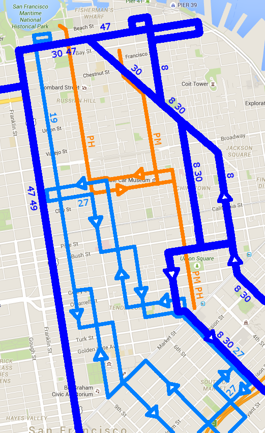
We should also allow easy transfers to east-west lines in the area, which would be the 1, 2, 3, 5, 10, 12, 30, 31, 38, 45, and 47. Of these, the 1, 5, 30, 38, and 47 are part of the frequent grid, so connections with these are especially important.
Designing the line
Our first instinct might be to use both streets in a one-way split, but one-way splits have a number of drawbacks. They make lines more confusing, as I talked about last time. They also reduce the area that is within walking distance of both directions of the line—a good explanation of why (and why we want to avoid this) can be found here, with diagrams. Our hope is to minimize use of one-way splits where possible.
Leavenworth and Jones are zoned similarly in Nob Hill and Russian Hill, so that’s not going to inform our decision. Since the 19 exists on the Van Ness side, and northbound buses south of Geary are further away than Stockton, let’s try Jones first.
North of California, Jones is a two-way street, so we’ll use it for both directions of this new bus line. Most buses in this area go up to North Point, so that’s our main destination, and then riders will easily be able to transfer to the 47 to head east and west. The 30, E and F are also very close to North Point & Jones. We’re also going to need to turn the bus around, and we can do so with a small one way loop like on the 19, extending from North Point to Beach.
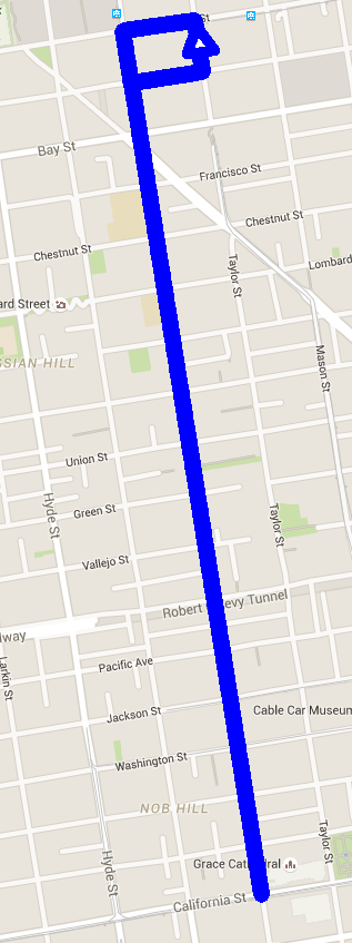
If we look closely at this map, though, we’ve done something impossible—Columbus Ave has a median in some areas, and one such place is right where Jones would cross it. We can’t go through here. Our proposal might include breaking up this median and only allowing Muni vehicles to cross. This would require a lot of extra signaling and would complicate traffic patterns on Columbus that the median was presumably intended to simplify, so I’m going to consider this unsatisfactory. We can look at some changes in routing that avoid this problem section of Columbus.
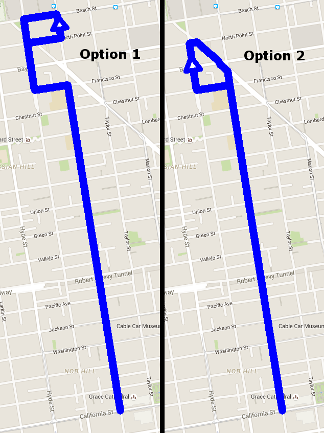
Both strategies take us to North Point. Each one has its own complication: the first suggestion makes the line a bit wiggly, and the one-way loop terminating the second option is needlessly large. I’ll choose the first option for now.
Below California, Jones is a one-way street running south. We can make the bus use Leavenworth for the northbound leg, turn right on California, left on Jones, and continue up with the path as mentioned before. We’re trying to avoid one-way splits as much as possible, but here it seems justified. These streets are one-way, and since they are less than 500 feet apart, the one-way split doesn’t affect the service area too much.
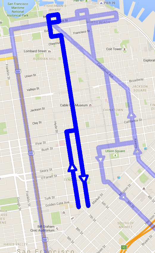
For now we are running the bus down to McAllister, which is right before it hits Market. Let’s try out our route. We send an imaginary bus up from Market on Leavenworth, where it turns right on California, and left up Jones. We get to Green St and start going down a huge hill… in fact, this hill is so steep that our bus goes into free-fall!
The steepest grade any Muni vehicle negotiates is 22.8%, which is along the 24-Divisadero as it travels on Noe St between 26th St and Cesar Chavez. The 24 uses trolleybuses specifically because this hill was too steep for motorcoaches to climb at the time. Modern motorcoaches can do the job, as you might find when a Castro street fair closes off a whole bunch of streets and they can’t use the overhead wires anymore. The buses and trolleybuses might be able to transit steeper grades, but we’ll consider it an upper bound for now, since we don’t actually know if anything steeper will work. Jones between Green and Union is a 26.2% grade—even if we could get down this hill, it’s immediately followed by a 29% grade between Union and Filbert, and going back up later is definitely out of the question. (You can find official grade maps here.)
We can try and route around this hill as well, but we risk making the route too complicated. I’d rather move the base of the route from Jones to Leavenworth. The steepest part of the line north of California is a comfortable 22.2% grade between Union and Filbert, and the end of our route already moves over to Leavenworth anyway. This generally serves the same area while keeping the line as simple as possible. We’ll still try to use Jones south of California because Leavenworth is one-way northbound during that segment.
Let’s try the imaginary bus again. We send it up Leavenworth, where it makes it all the way to North Point, loops around and starts back towards Market. We come down to California, make a left and then a right around the odd guard rail… and promptly bottom out on the crest! Jones has a 24.7% grade between California and Pine, so putting a bus on it is not a safe bet. This means we can’t use Jones here, either! We have to explore some backup plans.
- Use Hyde to get to Bush or Post, take it to Jones, and use that to go towards Market.
- Use Mason to get to Pine or Sutter and take it to Jones.
- Use Hyde the whole way down to Market.
- Turn one lane of Leavenworth into a contraflow bus lane.
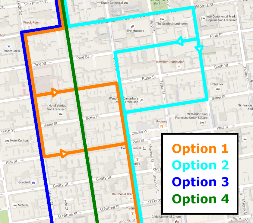
Option #1 recreates some of the leapfrog one-way splits we saw in the confusing 27 route, which we’re trying to avoid in creating this line, so that’s not a good idea. Option #2 entails a 3 block wide one-way split, which is one of the problems with the 8 and 30 that we are trying to work around by having a mid-Tenderloin line. Option #3 is workable, but risks nudging the service area a little too close to the Van Ness bus brigade. It does not require drastic infrastructural changes, so we can keep it on the table for now.
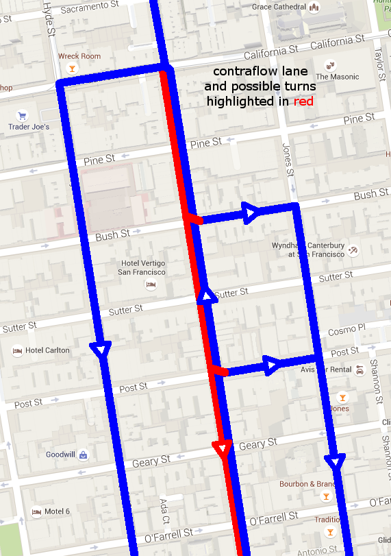
Option #4 is very interesting. Contraflow bus lanes are often used to turn one-way streets into two-way streets for transit purposes. Other traffic will only be able to go northbound on Leavenworth, but buses will have exclusive access to a southbound lane. I don’t believe they are currently used in San Francisco. This requires a little bit of infrastructure work such as painting the lane red and adding proper signage, as well as adding traffic lights at each intersection. An intermediate proposal might use a contraflow lane for a short time until the bus can get over to Jones, probably via Bush or Post. However, Leavenworth is a large street south of Geary. If we are going to use the contraflow lane north of it to avoid the California crest on Jones, we might as well take a lane out of the wide part to improve simplicity and speed.
Here are our possible alignments:
Through any of these options, we can connect Fisherman’s Wharf with Market at Civic Center Station.
Stop selection
Local buses in San Francisco stop every two to three blocks, so we can follow this model when picking stops. Ideally, we want to line up the stops with the east-west lines, so we can maximize its usefulness as a grid line.
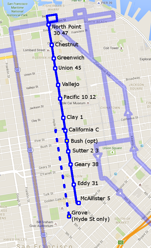
If both the northbound and southbound trips use Leavenworth, then all of the stops north of Market are marked here. If we use Hyde for the southbound leg, we can use the same set of cross streets, but we’ll want an extra stop on Grove before continuing southeast on 8th St. The McAllister and Grove stops are very close to Civic Center Station. I also added an optional stop on Bush to serve the hospital more directly, since hospitals are destinations that you might want to add stops next to even if there are other stops nearby. For precedent on this in the current Muni network, check out the 9R-San Bruno Rapid, which stops in front of SF General Hospital on Potrero Ave even though it stops again one block away on 24th St.
Unfortunately, we are not done—this route only takes us to Market, and grid lines are more useful when you don’t have to think about where they start and stop. In the next installment, I’ll draw the rest of the line south of Market, and we can decide what a good anchor for the other side of this frequent line would be.